FAA INFORMATION EFFECTIVE 17 DECEMBER 2009
Location
| FAA Identifier: |
EWB |
| Lat/Long: |
41-40-34.1100N / 070-57-24.9900W
41-40.568500N / 070-57.416500W
41.6761417 / -70.9569417
(estimated) |
| Elevation: |
80 ft. / 24.4 m (surveyed) |
| Variation: |
16W (1995) |
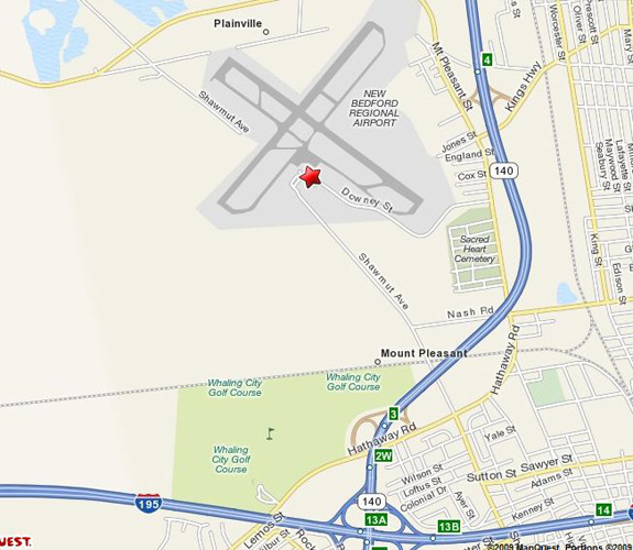
| From city: |
2 miles NW of NEW BEDFORD, MA |
| Time zone: |
UTC -5 (UTC -4 during Daylight Saving Time) |
| Zip code: |
02745 |
Airport Operations
| Airport use: |
Open to the public |
| Activation date: |
04/1942 |
| Sectional chart: |
NEW YORK |
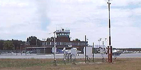
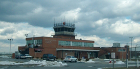
| Control tower: |
yes |
| ARTCC: |
BOSTON CENTER |
| FSS: |
BRIDGEPORT FLIGHT SERVICE STATION |
| NOTAMs facility: |
EWB (NOTAM-D service available) |
| Attendance: |
0600-0000 |
| Wind indicator: |
yes |
| Segmented circle: |
no |
| Lights: |
DUSK-DAWN
WHEN ATCT CLSD ACTVT HIRL RY 05/23; MIRL RY 14/32; MALSR RYS 05 & 23; REIL RY 32 - CTAF. VASI RYS 23 & 32 OPER 24 HRS. |
| Beacon: |
white-green (lighted land airport) |
| International operations: |
customs landing rights airport |
Airport Communications
| CTAF: |
118.1 |
| UNICOM: |
122.95 |
| ATIS: |
126.85(508)994-6277 |
| WX ASOS: |
PHONE 508-992-0195 |
| NEW BEDFORD GROUND: |
121.9 [0700-2200] |
| NEW BEDFORD TOWER: |
118.1 239.0 [0700-2200] |
| PROVIDENCE APPROACH: |
128.7 |
| PROVIDENCE DEPARTURE: |
128.7 |
| EMERG: |
121.5 243.0 |
| WX ASOS at TAN (12 nm N): |
132.675 (508-824-5005) |
| WX ASOS at UUU (17 nm SW): |
132.075 (401-846-5910) |
| WX ASOS at PYM (17 nm NE): |
135.625 (508-746-8003) |
- APCH/DEP SVC PRVDD BY BOSTON ARTCC ON FREQS 124.85/307.9 (WOODSTOCK RCAG) WHEN PROVIDENCE APCH CTL CLSD.
Nearby radio navigation aids
| VOR radial/distance |
|
VOR name |
|
Freq |
|
Var |
| PVDr112/21.4 |
|
PROVIDENCE VORTAC |
|
115.60 |
|
14W |
| MVYr332/22.8 |
|
MARTHAS VINEYARD VOR/DME |
|
114.50 |
|
15W |
| NDB name |
|
Hdg/Dist |
|
Freq |
|
Var |
|
ID |
| TAUNTON |
|
183/12.3 |
|
227 |
|
16W |
|
TAN |
- .- -. |
| PLYMOUTH |
|
230/12.4 |
|
257 |
|
16W |
|
FFF |
..-. ..-. ..-. |
| MANSFIELD |
|
167/22.3 |
|
220 |
|
16W |
|
IHM |
.. .... -- |
| MARSHFIELD |
|
222/28.3 |
|
368 |
|
16W |
|
IMR |
.. -- .-. |
Airport Services
| Fuel available: |
100LL JET-A |
| Parking: |
hangars and tiedowns |
| Airframe service: |
MAJOR |
| Powerplant service: |
MAJOR |
| Bottled oxygen: |
HIGH/LOW |
Runway Information
Runway 14/32
| Dimensions: |
5000 x 150 ft. / 1524 x 46 m |
| Surface: |
asphalt, in fair condition |
| Weight bearing capacity: |
| Single wheel: |
33.0 |
| Double wheel: |
48.0 |
| Double tandem: |
95.0 |
|
| Runway edge lights: |
medium intensity |
|
RUNWAY 14 |
|
RUNWAY 32 |
| Latitude: |
41-40.817833N |
|
41-40.305600N |
| Longitude: |
070-57.836083W |
|
070-56.976533W |
| Elevation: |
76.9 ft. |
|
66.9 ft. |
| Gradient: |
0.2% |
|
0.2% |
| Traffic pattern: |
left |
|
left |
| Runway heading: |
144 magnetic, 128 true |
|
324 magnetic, 308 true |
| Markings: |
basic, in fair condition |
|
basic, in good condition |
| Visual slope indicator: |
|
|
4-box VASI on left (3.00 degrees glide path) |
| Runway end identifier lights: |
|
|
yes |
| Touchdown point: |
yes, no lights |
|
yes, no lights |
| Obstructions: |
14 ft. tree, 400 ft. from runway, 14:1 slope to clear |
|
20 ft. trees, 600 ft. from runway, 20:1 slope to clear |
Runway 5/23
| Dimensions: |
4997 x 150 ft. / 1523 x 46 m |
| Surface: |
asphalt, in fair condition |
| Weight bearing capacity: |
| Single wheel: |
30.0 |
| Double wheel: |
108.0 |
| Double tandem: |
195.0 |
|
| Runway edge lights: |
high intensity |
|
RUNWAY 5 |
|
RUNWAY 23 |
| Latitude: |
41-40.301417N |
|
41-40.945867N |
| Longitude: |
070-57.870817W |
|
070-57.188450W |
| Elevation: |
65.9 ft. |
|
79.7 ft. |
| Gradient: |
0.3% |
|
0.3% |
| Traffic pattern: |
left |
|
left |
| Runway heading: |
054 magnetic, 038 true |
|
234 magnetic, 218 true |
| Displaced threshold: |
no |
|
413 ft. |
| Markings: |
precision, in fair condition |
|
precision, in fair condition |
| Visual slope indicator: |
|
|
4-box VASI on left (3.10 degrees glide path) |
| RVR equipment: |
touchdown |
|
|
| Approach lights: |
MALSR: 1,400 foot medium intensity approach lighting system with runway alignment indicator lights |
|
MALSR: 1,400 foot medium intensity approach lighting system with runway alignment indicator lights |
| Touchdown point: |
yes, no lights |
|
yes, no lights |
| Instrument approach: |
ILS/DME |
|
|
| Manager: |
EDWARD J. DEWITT
1569 SHAWMUT AVE
NEW BEDFORD, MA 02746
Phone 508-991-6160 |
|